


marcilly en villette_ ouest_La Bohardiere

lemuid
User
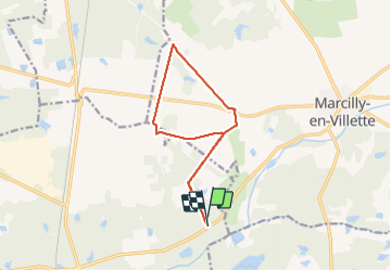

Length
11.9 km

Max alt
131 m

Uphill gradient
79 m
Km-Effort
13 km

Min alt
107 m

Downhill gradient
79 m
Boucle
Yes
Creation date :
2022-02-04 08:04:53.8
Updated on :
2022-02-04 16:54:16.289
2h13
Difficulty : Easy

FREE GPS app for hiking
 SityTrail
IGN / Geographical institutes
SityTrail Plus
The world is yours!
About
Trail Walking of 11.9 km to be discovered at Centre-Loire Valley, Loiret, La Ferté-Saint-Aubin. This trail is proposed by lemuid.
Positioning
Country:
France
Region :
Centre-Loire Valley
Department/Province :
Loiret
Municipality :
La Ferté-Saint-Aubin
Location:
Unknown
Start:(Dec)
Start:(UTM)
423435 ; 5287886 (31T) N.
Comments